


About
Programme
Individual Scientific
Sessions
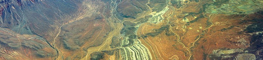
Section 1: Earth and Humankind – Geo-hazards, geo-resources (including geothermal energy)
and sustainability
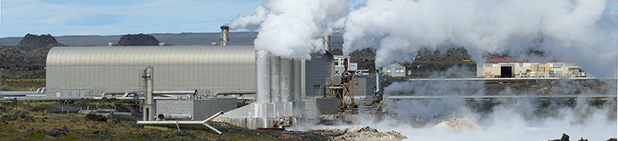
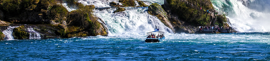
1.1 'Characterizing the Subsurface for more please click to learn moreSustainable Energy and Storage'by Guido Hoetz (1), Martin Ecclestone (1) and Jurgen Grotsch (2); 1: EBN, The Netherlands; 2: Jurgen Grotsch, The NetherlandsAtmospheric CO2 concentration continues to rise. To tackle resulting climate change, the need to reduce, halt and ultimately reverse the net release of CO2 into the atmosphere from the burning of fossil fuels is well understood. However, energy derived from fossil fuels will need to remain part of the energy mix for some time, so that the rising global demand for energy can be met. To reconcile this contradiction, and to avoid irreversibly damaging environmental conditions on earth, the ongoing energy transition will require a major acceleration in both the deployment of technologies that provide sustainable energy economically and technologies that capture and sequester CO2 safely, securely and permanently. With this context in mind, this session focuses on energy transition related topics including: a) How will the target of net zero CO2 and resulting transition in the energy mix to more sustainable energy sources change the role of geoscientists within the E&P industry; b) Is there further scope for E&P drilling related geoscience knowledge, skills and processes to be scaled and leveraged by sustainable energy and CCUS companies; c) How modelling of heat and mass transfer within geothermal reservoirs is providing insights into reservoir temperature and the hydraulic characteristics that control exploitable thermal energy resources and helps delineate and support exploration for renewable energy supply; d) The importance of understanding the impact of natural fractures on fluid flow and heat production from low permeability geothermal reservoirs; e) How micro-seismic monitoring is being used as part of a CCUS risk-based measurement, monitoring and verification (MMV) framework to evaluate the storage performance by monitoring conformance and containment; f) Geo-drilling hazards and how associated risks can be mitigated to improve the safety and effectiveness of drilling operations for geothermal and CCUS projects.
1.2 'Applications in 3D Geological Modelling'by Rouwen Lehne (1) & Michiel van der Meulen (2); 1: HLNUG Geological Survey of Hesse, DE, 2: TNO Geological Survey of the Netherlands, NLOver the last decades, 3D geological modelling has become a standard in hydrocarbon exploration and production, has been adopted and is developing towards a systematic effort by geological surveys, and is on the verge of being able to properly handle the structurally complex settings in which the mining sector operates. New, exciting possibilities are arising and new application domains are opening up, which challenges geomodellers to integrate data and methods from different domains (e.g. remote-sensed and subsurface data), and to deliver integrated content (e.g. urban underground infrastructure and geology). In this process, several hurdles must be overcome, i.e., developing standards, harmonization, integration of data, storing and sharing content in a structured manner, and developing services. In the process challenges are manifold, and so are the solutions.This session therefore is looking for contributions addressing the wide field of geological 3D-modelling and associated topics such as data modelling & data storage and sharing systems. We especially encourage the younger generation to present and are glad to announce a special block within the session that is dedicated to honor selected student degree theses and reward them with a cash prize. For more details please visit the website of the section Geoinformatics (www.fgi-dggv.de). 1.3 'Radon & Geology'by Rouwen Lehné1, Eric Petermann2; 1: HLNUG, Germany; 2: BfS, GermanyThe radioactive gas radon belongs, together with terrestric and cosmic radiation, to the natural sources of radioactive radiation. For Germany e.g. the average exposure coming from radon is about 1.1 mSv/a (Bundesamt für Strahlenschutz, 2016), which makes up more than 50 % of the total natural radiation exposure.With the 2013/59/EURATOM directive of the EU-Commission, the EU member states were urged to update their radiation protection laws to account for the health risk of the exposure to elevated indoor radon levels and to prepare National Radon Action Plans (EC 2014). The EU member states have to provide information on so called “radon priority areas” by the end of 2020. The basis for the identification of those areas will be the map of geogenic radon potential (a function of radon soil gas concentration and soil gas permeability). In many cases (i.e. for many countries or regions) the currently available data is not sufficient to provide a satisfying accuracy, leading to the need of additional field measurements. The selection of sampling sites ideally reflects both 1) the administrative level on which radon-priority area will be delineated and 2) available knowledge about variability of landscape characteristics governing the geogenic radon potential (rock, soil, water characteristics, etc.). However, while the influence of soil and rock on the radon concentration is fairly understood, the impact of tectonic inventory and hydrogeological aspects (e.g. origin, flow direction and flow velocity) cannot be considered schematically but require site-specific awareness and treatment. This session therefore is inviting contributions from the large field of action related to radon & geology. The topics include but are not limited to: Approaches in planning measurements Methodological experiences Results and interpretations so far Temporal and spatial variability Influence of local phenomena From measurements to maps: how to predict spatially1.4. ''Raw Materials and their societal relevance for Europe’ by Antje Wittenberg, Henrike Sievers; Federal Institute for Geosciences and Natural Resources (BGR), GermanyRaw Materials are crucial components of a vital and wealthy society. This holds for societies affected by mining, manufacturing and agriculture as well as for those that reached a de-industrialised status. Sustainable supply of raw materials always calls for accessibility to mineral deposits and productive mines. It is getting more and more challenging to meet these needs not only due to the competing land-use issues and to provide a fair share of costs and benefit to all. The realisation of a low-carbon society and a self-concept of reliable sourcing increasingly require short feed strokes and local sourcing. Although Europe has a long history in mining, it is still widely underexplored in particular with modern exploration methods. A good understanding of mineral systems, mining sites and remaining resources of historical sites is still of utmost importance. This session invites contributions from the entire mining cycle spanning from raw materials exploration to active mining in Europe indicating a socio-economic importance to our society in particular.Fridays For Future, UN SDG, EC Green Deal and many more are focussing on issues towards a carbon neutral economy. All those aspects need actions by Geoscientists and will put pressure on the raw materials demand side. 1.5. 'Recent advances in engineering geology and geohazards modelling' by Anika Braun, Tomas Fernandez-Steeger; Technische Universität Berlin, GermanyThe session addresses recent research and studies in the field of engineering geology and geohazards modelling. We welcome in particular the applied research of students, young professionals and early career scientists. First results and findings from recent projects as well as challenges and solutions from industry or consulting projects showing the relevance of geoscience for engineering solutions are welcomed.1.6. 'Societal challenges with focus on water, induced seismicity and subsidence' by Thibault Candela (1) and Liviu Matenco (2); 1: TNO, The Netherlands; 2: Utrecht University, The NetherlandsThe session presents contributions in the fields relevant to societal development, such as water resources and quality, subsidence and induced seismicity.
Section 2: Earth Evolution – Multi-scale past climate, environmental and fauna evolution
2.1 'Latest Achievements in Scientific Ocean and Continental Drilling'by Martin Ziegler1, Timme Donders1, Jan Behrmann2, Lucas Lourens1; 1: Utrecht University, Netherlands; 2: GEOMAR, Kiel, GermanyNational and international Earth science programs are utilizing Scientific Drilling as a critical tool to understand climate and environmental variability, natural hazards such as earthquakes and volcanic eruptions, natural resources, the deep biosphere and other topics of socio-economic relevance. The principal goal of the session is to summarize latest scientific achievements in ocean, continental and polar drilling.2.2 'The imprint of astronomical climate forcing: geochronometer and paleoclimate archive'by Christian Zeeden1, Diederik Liebrand2, Anna-Joy Drury3, Stefanie Kaboth-Bahr4, Qiang Fang5; 1: Leibniz Institute for Applied Geophysics, Hanover, Germany; 2: MARUM, Bremen, Germany; 3: University College London, London, UK; 4: University of Potsdam, Potsdam, Germany; 5: China University of Geosciences, Beijing, ChinaThe pacing of the global climate system by variations in orbital parameters is clearly demonstrated in the timing and specific patterns of e.g. sapropels and glacial-interglacial cycles beside many other examples. The imprint of astronomical cycles can be used as high-precision geochronometer, and as paleoclimatic information.We invite contributions utilizing the imprint of Milankovic cycles as preserved in the geological record in any way. This includes the often not very well understood mechanisms that translate this forcing into geoarchives. Submissions exploring proxy data and/or modelling work are welcome; we aim to bring together proxy-based, theoretical and modelling studies focused on global and regional climate responses to astronomical forcing at different time scales. 2.3 'Proxy applications in restricted basins'by Iuliana Vasiliev-Popa1, Wout Krigsman2; 1: Senckenberg Biodiversity abd Climate Research Centre, Germany; 2: Earth Sciences, Utrecht University, The NetherlandsDuring the Miocene the Mediterranean-Paratethys system experienced, at times, severe disruption of connectivity to the ocean, limiting the possibility for strait forward correlation of conventional proxy data (e.g. δ13C & δ18O stable isotopes) to the oceanic record. It is, however, important to understand the paleoenvironmental changes affecting this highly-dynamic Mediterranean-Paratethys system, especially at times of almost complete separation from the Open Ocean like during the times of Badenian and Messinian Salinity Crises, two events that shaped the Eurasian paleoclimate. This session is intended to bring together all-type proxies specialists working in the Mediterranean-Paratethys domain with the target to obtain an integrated understanding of the potential in using novel geochemical proxies to reconstruct parameters like anoxia, sea surface temperature, salinity, mean annual air temperature, all influenced by the size of the gateways and the connectivity to the Ocean. These geochemical proxies are intended to be paralleled to the more established proxy data provided by palaeontology and palynology to understand and cross-evaluate the limitations of proxies in restricted basins. We also encourage contributions where the proxy records are used and compare to modelling experiments for achieving a holistic understanding of changed affecting highly restricted basins.
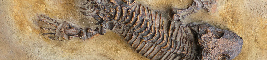
2.4 'Mammalian adaptation and evolution throughout the Cenozoic'by Anneke H. van Heteren1,2,3, Wilma Wessels4; 1: Mammalogie Section, Bavarian State Collection of Zoology; 2: GeoBio-Center, Ludwig-Maximilians-Universität München; 3: Systematic Zoology, Ludwig-Maximilians-Universität München; 4: Department of Earth Sciences, Utrecht UniversityCenozoic mammals are the textbook illustration of an adaptive radiation. Adaptive radiations have taken a key position in macroevolutionary theory and were originally introduced after the qualitative observation that great taxonomic diversity and ecomorphological disparity of mammals emerged suddenly in the earliest Cenozoic. This has been construed as a product of the ecological release of mammals following the extinction of many species, including all non-avian dinosaurs, during the Cretaceous/Palaeogene (K/Pg) mass extinction event. The radiation of mammals after this event was, as such, a significant event in the evolution of terrestrial and marine ecological communities.Paleogeographic changes and climatic changes affected the distribution, evolution and ecology of mammalian species and communities throughout the Cenozoic. Climatic change altered the abundance, genetic diversity, morphology, and geographic ranges of individual species. Within communities, these responses combined to initiate migration, biological evolution, and extinction, altering longstanding patterns of community stability and diversity and inducing functional innovation and biotic turnoversKnowledge of the mechanisms at the heart of biological change generates meaningful understanding of the intricacies of the mammalian response. This session, therefore, is looking for contributions concerning vertebrate palaeontology, notably on Cenozoic mammals. The talks in this session may range from insectivores and rodents to mammoths, sabretooth cats, and cetaceans. This session will be in honour of Prof. Jelle Reumer, who recently retired. The last 15 years, he worked as a professor at Utrecht University, where he upheld vertebrate palaeontology in teaching and research, as well as through collaborations with other researchers and laymen.Prof. Jelle Reumer will give the keynote lecture for this session.
Section 3: Deep Earth – Structure and modelling, sediment dynamics
3.1 'Microfabrics, deformation mechanisms and rheology'by Jolien Linckens1, Hans de Bresser2; 1: Goethe University Frankfurt am Main, Germany; 2: Utrecht University, NetherlandsThe investigation of microfabrics, i.e. microstructures and textures (CPO) of rocks, is essential for the understanding of deformation in the micro- and macroscale and thus the rheology of the Earth’s crust and mantle. Rock microstructure and CPO allow to compare deformation in nature and experiment and to derive deformation mechanisms. Derived deformation mechanisms and the resulting understanding of rock rheology are the basis for the extrapolation of laboratory data to natural deformation and its kinematics at all scales.For this session, we welcome contributions from the entire field of microfabrics investigations and their applications to natural and experimental rock deformation, geomechanical and tectonic modeling, as well as petrophyscial property studies.
3.2 'Advances in understanding processes driving the formation and evolution of sedimentary basins'by Liviu Matenco1, Magdalena Scheck-Wenderoth2, Fadi Henri Nader3; 1: Utrecht University, The Netherlands; 2: GFZ Potsdam and Aachen University, Germany; 3: IFPEN Rueil Malmaison, France and Utrecht University, The NetherlandsThis session addresses the dynamics of sedimentary basins at different temporal and spatial scales and aims to bring together a wide range of studies focusing on geodynamics, tectonics and sediment dynamics. Contributions addressing major processes affecting the genesis and evolution of basins are in particular encouraged (from rifting and overlying passive continental margins to orogenic, intra-montane and extensional back-arcs in convergent settings). A wide range of studies are encouraged, aimed at understanding the evolution of sedimentary fill, the underlying crustal and lithospheric -scale dynamics as well as the integration with processes taking place in the source areas, such as active orogens or long-term landscape evolution. We welcome contributions integrating data from different depth levels of the lithosphere with the shallower parts of the basin system as subsidence pattern, stress, vertical motions, erosion and sedimentation dynamics, thermal structure, lithosphere dynamics and (active) faulting by the means of observational studies, numerical and analogue modeling, or their combination. Studies yielding constraints on a variety of conceptual and quantitative models explaining the origin and evolution of basins are also welcomed.Session sponsored by the International Lithosphere Program Task Force VI Sedimentary Basins
3.3 'Tectonics, geodynamics, and paleogeography of the Alpine-Himalayan orogen from the Earth’s mantle to its surface'by Maud J.M. Meijers(1) & Douwe J.J. van Hinsbergen (2); 1: Senckenberg Biodiversity and Climate Research Centre, Germany; 2: Department of Earth Sciences, Utrecht UniversityOngoing Africa-Eurasia has led to the near-disappearance of the Tethys Ocean and the formation of a series of orogens from the Alps in the west to the Himalayas in the east. The Tethyan belt was formed during subduction, obduction, accretion, and collision of numerous Gondwana-derived crustal fragments, intervening oceans, and the Indian and Arabian continents. Subducting oceanic and continental crust led to accretionary orogenesis along the belt. Overriding plate deformation caused back-arc basin opening (especially in the Mediterranean region) and overriding plate shortening led to orogenic plateau formation. The Alpine-Himalayan orogen includes a series of such orogenic plateaus that increase in elevation and surface area from west to east: the Anatolian, Iranian and Tibetan plateaus, and a plateau may have existed in the past in the modern Balkan-Carpathian region. Particularly the Tibetan plateau presently modifies northern hemisphere atmospheric circulation and hence affects climate patterns.In this session, we seek to attract abstracts from geoscientists that study the geodynamic, tectonic, and paleogeographic evolution of the Tethyan realm in a multidisciplinary fashion. We are particularly interested in studies that focus on the interactions and coupling between mantle, crustal and/or surface processes that were responsible for shaping the Tethyan realm and its associated orogens and mountain belts throughout geological time. 3.5 Forward and inverse modelling of tectonic processesby Ylona van Dinther1, Boris Kaus2; 1Utrecht University, The Netherlands, 2University of Mainz, Germany Numerical and analogue models improve our understanding of – and predictive power for – tectonic processes occurring across a wide range of spatial and temporal scales. These processes tend to be complex and interesting because of their multi-physics and cross-scale nature, including hydrological, thermal, chemical and mechanical components from billions of years down to milliseconds and global to micrometer scales. We invite contributions concerning development and application of physics-based forward and inverse models addressing topics ranging from plate tectonics, mantle and lithosphere dynamics, magmatism, fluid flow, to seismicity. 3.6 Tectonic systems (TSK Open Session)by Nikolaus Froitzheim1, Kamil Ustaszewski2, Michael Stipp3; 1: Universität Bonn, Germany; 2: Universität Jena, Germany; 3: Universität Halle, GermanyWe invite contributions from the fields of tectonics, structural geology, and crystalline geology. Regional and process-oriented studies from all kinds of active or fossil tectonic settings are welcome – rifting, subduction, collision, transform, and intra-plate deformation. Studies dealing with the development of methods related to the deformation of crust and lithosphere from micro-scale to plate scale are also invited.
3.7 'The Alpine Orogen: Reconciling Recent Images of its Deep Structure and Crustal Tectonics'by Thomas Meier1, Jan Behrmann2, Eline LeBreton3, Wim Spakman4; 1: Christian-Albrechts Universität Kiel, Germany; 2: GEOMAR Kiel, Germany; 3: Freie Universität Berlin, Germany; 4: Utrecht University, The NetherlandsThe Alps provide the fascinating opportunity to study the complexity of mountain building processes because of the availability of extensive and detailed geological and geophysical data sets. The highly arcuate geometry of the Alpine chain originated in the Neogene, when previously southeast-directed subduction gave way to hard collision and indentation in the western, central, eastern Alps, and to roll-back subduction in the Carpathians and Apennines, respectively. The Alps Mountains are composed of deformed and amalgamated crustal slices derived from Eurasia, Adria, the intervening Brianconnais microcontinent and the Piemont-Ligurian and Valais oceanic basins. The driving forces of collision are however still less understood because segments of mantle lithosphere subducting beneath the Alps remain poorly imaged. Examples for open questions are: Down to which depth is Eurasian mantle lithosphere subducting eastwards beneath the western Alps? Is there evidence for Eurasian slab break-offs? Is Adria subducting northwards beneath the eastern Alps? Furthermore, the deformation of crustal units in the core of the orogen as well as the tectonic uplift in the western Alps and the eastward lateral escape in the eastern Alps north of the Periadriatic Fault remain to be understood quantitatively. New images of the Alpine deep structure using data of AlpArray and complementary projects are becoming available. We invite contributions on the interpretation of geophysical images of the Alpine crustal and upper mantle structure as well as on the analysis of surface deformation and tectonics aimed to cross-fertilise discussions on quantitative tectonic models able to explain mountain building in the Alps. Specifically, we want to focus on coupling models of the Alpine deep structure with multi-scale (near-)surface observations.3.8 'Early Earth and Life: Insights from recent research in the Barberton Greenstone Belt' by Christoph Heubeck (1) & Paul Mason (2); 1: University of Jena, Germany; 2: University of , Utrecht, The NetherlandsEarly Earth was very different compared to the planet we are used to, including the absence of plate tectonics and a paucity of continents, a "soft" lithosphere, widespread volcanism, an anoxic, high-CO2 atmosphere and oceans linked to an aggressive weathering regime, a close Moon and a harsh but faint sun, "frequent" meteorite impacts and many others. Arguably, these conditions offered friendlier environments to microbial life than any time since. This session will focus on surface dynamics and processes documented by recent research in one of the foremost archives of the Paleoarchean, the Barberton Greenstone Belt of South Africa and Eswatini.
Section 4: Data infrastructure, education and open topics in the Earth System
4.1 'Working on the roads: improving the infrastructure for research into geo-societal challenges'by Ronald Pijnenburg1, Kirsten Elger2; 1: Utrecht University, Netherlands; 2:GFZ, GermanyIn response to the growing and complex geo-societal challenges of our densely populated planet, current research frequently requires convergence of multiple research disciplines, and optimized use of currently available data, research facilities and funds. Especially the Earth and environmental sciences play a significant role in addressing these challenges, but will require the integration of scientific data, software and tools from multiple, globally distributed resources to unlock their full potential to contribute. The preconditions for interdisciplinary research are set by existing national- and continental-scale research infrastructures (e.g., EOSC, ENVRI, EPOS, EarthCube, AuScope, etc.). Utilization of these infrastructures has significantly advanced ongoing research into geo-societal issues globally. It is now key to further develop these infrastructures, identify current/potential challenges, enhance effective outreach to users, policy makers and funding partners and so to increase the efficiency of future research into the challenges that come with the pervasive use of our planet.This session invites contributions from different fields of expertise, including infrastructure managers, data scientists, interdisciplinary researchers and policy makers. Our aim is to discuss perspectives, experiences, current or future challenges and potential solutions related to creating an effective infrastructure for the environmental and earth sciences.
4.2 'Higher education teaching and outreach in Geosciences'by Martin Meschede1, Hans de Bresser2; 1: Institut für Geographie und Geologie, Greifswald, Germany; 2: Faculty of Geosciences, Utrecht University, The NetherlandsInput from the Geosciences is essential in addressing many of the challenges facing society. We do not only need to prepare our graduates so that they can provide such input, but we also have a task to inform the general public on our way of help solving Geoscientific problems. In this session, we aim to present new approaches and techniques in higher education teaching in Geosciences as well as effective outreach activities. It may cover the introduction of blended learning programmes and new approaches to actively engage students in class, the application of augmented and virtual reality, digital mapping and class room response systems, and original and innovative ideas on educating people other than students. And more. We hope that a range of contributions will come together that forms a source of inspiration for further developments in higher education and outreach in Geosciences.
4.3 'Open topics in the Earth System' by Liviu Matenco and Jürgen GrötschWe welcome here general contributions where the authors feel that topical sessions do not cover their research or study subject.
Virtual
Conference Centre
Detailed programme,
abstracts &
presentation material
We cordially like to thank our exhibitors & sponsors – please click on the logos to learn more: